 | What preceded this: |
NOTE: "Canada" is a corruption of an Odawa [Ottawa] word, Kanata, meaning "villages" |
Historical Chronology and Relevant Links
Major Recorded Disease epidemics
- 1615-22 -- Smallpox; Chesapeake and Delaware Bays and inland
- 1616-20; 1633-35; 1660 -- Smallpox; All three epidemics were widespread through New England and the Haudenosee League tribes
- 1630 -- Smallpox, hit all tribes north of Lakes Huron, Erie, Ontario. Not recorded, but probably out to the seacoast north of Gulf of St. Lawrence.
- 1746 -- Typhoid, Nova Scotia tribes
HISTORICAL CONTEXT SUMMARY TIMELINE
- 1498: English explorer John Cabot, looking for Northwest Passage (to India) travels coast of Labrador, New Brunswick, Nova Scotia, discovering Newfoundland Island, trades furs with Mik'maqs.
- 1534: French explorer Jacques Cartier enters Gulf of St. Lawrence River. Ship becomes icebound, men suffering from scurvy aided by Haudenosee, who feed them vitamin C in boiled spruce.
- 1599 : Samuel de Champlain, French explorer, arrives, followed by Catholic missionaries.
- 1605-1607 : French built a permanent settlement at Port Royal on the Bay of Fundy, Nova Scotia, (later to be named Annapolis Royal by the British). The Europeans were welcomed by Mi'kmaq Grand Chief Membertou, who converts to Catholicism, makes a wampum-belt treaty with the Vatican
- 1621: Dutch West India Company chartered expands up the Hudson and Delaware rivers. Peter Minuit buys Manhattan Island in 1626 for 60 guilders worth of beads. Dutch policy is land payments to Indians, neutrality in Indian conflicts relating to French-English struggle. But after 1632, Dutch colonists begin to demand more farmlands. In 1639, Dutch governor-general William Kieft adopts policy of exterminating the hostile Indians and taxing the rest. Dutch soldiers aid Mohawk allies to carry out Pavonia massacre, where Dutch soldiers played kickball with the heads of the women and children refugees they had killed.
- 1622 -46: Powhattan Confederacy Wars, Chesapeake Bay area. Source of phoney Pocahontas tale by English Capt. John Smith, after Pocahontas's death (married to John Rolfe, she died in England). John Rolfe Jr. after growing up in England, returns to Virginia, claims his grandfather's land, kills or enslaves his mother's relatives. Has one child (female) by an upper-class white woman, proudly "dies an Englishman". Colony's racist laws about Indians make a "Pocahontas Exception" for the English descendants of Rolfe, which in 1924 is re-enacted by the U.S. Virginia State legislature, in racist laws about Indians and Blacks. English Countess Mountbatten and other rich white people are among the descendants of the unfortunate Powhattan girl, so the "one drop of inferior-race blood" statutes make this Pocahontas Exception just for them. These racist laws -- and the Pocahontas Exception (also racist) -- remained in force in Virginia until overturned in the Supreme Court decision Loving vs. Virginia, 1969. This wasn't in the Disney cartoon.
- 1633 (and after): English and French settlers enlist mainland Indians, mostly Mik'maq to massacre Beothuk people of Newfoundland, who are now extinct. "Red" Indian apparently derives from these people, who painted their bodies with red ochre. Nancy Shawanahdit, the last Beothuk, died in 1829. Little is known of their customs, language, religion. Beothuk was not likely their tribal self-name.
- 1636-37: Pequot War against the English. (Niantics, Narragansetts later joined). Capt. John Mason burnt sleeping Pequot village at Mystic River, pinning the people inside the flames by gunfire. Mohawks behead fleeing Pequot leaders to prove they were not involved.
- 1649 - 1664 the Beaver Wars: Encouraged by the English, and the need for more beaver for trade (their own area being hunted out), Haudenosee (Iroquois) make war on Hurons (1649), Tobaccos (1649), Neutrals (1650-51), Erie (1653-56), Ottawa (1660), Illinois and Miami (1680-84), and members of the Mahican confederation. English, pleased with this, agree to 2-Row Wampum Peace treaty, 1680.
- 1654-59: Pierre Radisson, French Sieur de Groselliers, encounters a lot of tribes throughout New France, New England, and what's now the U.S. midwest. Adopted by a Mohawk family, who take him to Hudson's Bay. There he changes sides and becomes English, participates in the formation of Hudson's Bay Company, and charter of Rupert's Land to it in 1670, deftly switching country allegiances several times France-England-France-England during the process. Ends up English. Today principally remembered by a hotel named after him in Minneapolis.
- 1660-64: In 1660, Dutch governor-general Peter Stuyvesant decides to hold Indian children hostage for the behavior of increasingly angry tribespeople. Hostages sold into Carribean plantation slavery. In 1664, English invade and conquer the Dutch area of New Netherlands, which becomes New York.
- 1670: Charles II (England) grants Hudson's Bay Company the charter to huge expanse of Rupert's Land around Hudson Bay. No treaties or compensation to Indian tribes there (mostly Ojibwe, Cree) till late 19th and early 20th century; no treaties ever made on large expanse east of Bay.
- 1675 - 76: Bacon's Rebellion -- Third major war between Virginia settlers and Virigina and Maryland Indians. Bacon's army kills and enslaves Susquehannock, Occaneechi, Appomatuck, Manakin, members of Powhattan Confederacy. Bacon leads brief rebellion against English Crown authority when his English military murderer commission is rescinded because of excessive brutalities.
- 1675- 76: Metacom's (King Phillip's) War against the English -- Wampanoag, later joined by Abenaki, Nipmucs and Narragansetts. Mohawks stay neutral; Mohegans, Pequots, Niantics, Masachusetts tribes back the English. Metacom loses. English government executes Metacom, nails body parts to town hall, sells wife, children, followers to plantation slavery.
- 1688-1697: King William's War -- Abenakis, Penobscot, other New England tribes, attacked by English and their Iroquois allies. This is the start of the French-English war for control of North America. England and France make temporary peace in 1697 (Treaty of Ryswick). French continue to pressure Iroquois, who eventually agree to (but don't hold) neutrality in the English-French conflicts. 1693 group of Maritimes Tribal treaties linked-to above comes from this war.
- 1696-97: European fur market collapses as fashion temporarily changes, leading to an increase in colonist settlers wanting permanent land. to clear and farm.
- 1702-1713: Queen Anne's War -- Maine Abenakis and Iroquois from Quebec (Caughnawaga) attack the English colonists on behalf of the French, but lose. All the New England (not Nova Scotia) treaties from the second group next to the map comes from this war. The European nations negotiated their settlement at the Treaty of Utrecht (1713); Louis XIV ceded Hudson's Bay and Acadia (Nova Scotia, and coastal and islands north of the St. Lawrence, parts of New France) to England.
- 1711-13: Turcarora War (North Carolina) -- Under the English Col. John Barnwell, then Col. James Moore, the Tuscarora Nation was repeatedly attacked, its chiefs tortured, its people sold (10 pounds sterling each) into slavery. The survivors fled northward and settled among the Haudenosee (Iroquois) 5 Nations.
- 1722: Haudenosee League admits Tuscarora as 6th Nation The refugee band was accepted according to the terms of the League Constitution. No other Native Nations had such a provision as this, other alliances and "confederations" were all temporary and informal.
- 1729: Natchez fight French -- at Fort Rosalie, when French governor Sieur Chepart tells them they must abandon the Temple Mound Great Village and move (as laborers) to his plantation. After the initial Indian successes, French lead two counter-invasions out of New Orleans, capturing and selling into plantation slavery most of the tribe and its smaller allies. A few bands live in hiding along the Mississippi River and continue their resistance.
- 1744, Treaty of Lancaster (English-Iroquois).
- 1748: Treaty of Logstown (English with Shawnee, Delware, Wyandot). English later base their claim to the whole Great Lakes and midwest (or Old Northwest as it was later called) on these two treaties.
- 1752: French kill Miami chief, fortify the Ohio Valley region with forts from Lake Erie to to the forks of the Ohio River
- 1752-59: The 7 Years' War, King George's War: -- English (in New Canada) and French (in New France) duke it out, with Indian allies on each side. Both sides build forts or fortify trading posts in Indian country on the above map. Choctaw, Tuscarora, Yamasee, Cherokee, some Creeks, fight against English; Mohawks, Chicasaw fight for English against French.
- 1755, English Explusion of the French Acadians -- who lived and intermarried with Nova Scotia and Cape Breton Miq'maks (many of whom were also taken). Forcibly loaded into ships and deposited randomly along the southern (now American) coasts, many (probably 1/3 to 1/2) died. Some are ancestors of the Cajuns of Louisiana, and a few made their ways back home. Acadians were idealists, hostile to King and Church authority, who lived in peace with the Miq'maks. Neither the French rulers nor the English wanted them.
- 1758: English begin capturing French fortifications, New France and Ohio Valley, the war started going their way decisively this year.
- 1759 English win most of Canada -- English commander Wolfe burns countryside, beseiges Quebec; defeats French commander Montcalm. Articles of Capitulation (surrender) signed 1759 at Quebec read "The savages or allies of his Most Christian Majesty shall be maintained in the lands they inhabit if they choose to remain there; they shall not be molested on any pretense whatsoever."
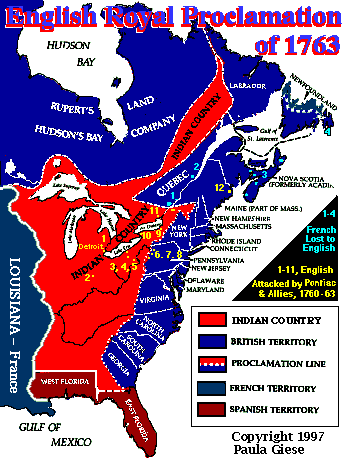
- 1760: Fall of Montreal and surrender of Great Lakes and Ohio Valley French forts to English. Lord Jeffrey Amherst starts a "get tough with Indians" policy, including the first biological warfare --smallpox-infested blankets (see documents link below). Amherst granted some Seneca (originally his allies) lands to his officers. Odawa chief Pontiac (and the Delaware Prophet) organize a resistance preaching return to traditional Indian customs. The 1761 draft Proclamation (to English governors, (linked-to above) and the Royal Proclamation (with a large Indian country in what's now the U.S. Great Lakes/Midwest) were part of the English Crown's attempt to mollify the Indians. Neither proclamation of undisturbed Indian lands was followed by settlers or the Crown.
- 1763: Treaty of Paris ends French-English conflict -- which included the European 7 Years War. France abandons claims to Rupert's Land, cedes all territory east of Mississippi, and New France, to England. France cedes West Louisiana to Spain, its ally (who lost Florida to England).
- 1763: Pontiac fails to take Detroit, because of informers alerting the English to his plans; as winter approaches, his army of Indians lost faith in victory, and returned to their homes. Aware that England and France had ended both their European and American wars, Pontiac tried to start a second uprising, later counseled peace, and was killed in 1769 in Illinois by a Peoria Indian who was probably an assassin hired by the English.
With England's victory over France in both North America and Europe, Indians -- especially the Haudenosee League (Iroquois) -- no longer held the balance of power between the English and French, and could no longer play them off against each other. Soon, in the south, the American Revolution got under way.
DATES OF ADMISSION TO PROVINCIAL STATUS
The relationship between provincial status and the numbered treaties is most clezaly shown for the western-prairie provinces. In the east, it had more to do with relationships to England.
- Eastern Provinces: Quebec (Upper Canada) , 1867; Ontario (Lower Canada), 1867; New Brunswick, 1867; Nova Scotia, 1867; Price Edward Island, 1873; Newfoundland (consolidated with Labrador), 1949.
- Manitoba: 1870 declared a provisional government in the first Riel (Metis-Cree-Anishinabeg) war, elected Riel repeatedly but he couldn't take office because he was under sentence of death in exile teaching school at the Blackfeet Nation in Montana. Admitted as province 1912.
- Saskatchewan: admitted as province, 1902
- British Columbia: admitted as province, 1871 (the railroad deal)
- Northwest territory: provisional status, 1991, most of it qwar id Hudson Bay and including most of the Arctic islands will become the (maybe) Inuit-controlled province of Nunavut in 1999 (or so).
LINKS TO (MOSTLY) PRE-CANADA ENGLISH TREATY-RELATED HISTORICAL INFO
- Several Wampum belt treaties -- pictures, translations
- The Conquest: Britain conquers Nouvelle France / la Conquête -- English/French switchable, from an educational service in Ottawa. [Gone]
- Native Peoples of North America and the Eighteenth-Century British Empire -- long historical document, full bibliography [Gone]
- Confronting Canada's Colonial Legacy (very long) all text, many bibliographical citations [Forbidden]
- 500 Years of Indigenous Resistance (very long), resistance to Canadian, Spanish, French -- and U.S. Many footnoted reference sources. [Forbidden]
- Mi'kmaq Reserves in Nova Scotia -- maps, band contacts info, from the website of Mike Sack, Indian Brook Mi'kmaq Reserve, Nova Scotia
- Self-answering Quiz about Acadia, you'll learn a lot by taking it. Scattered bits of Mi'kmaq involvement, but of course the Acadians were involved with Mi'kmaq clans via family ties.
- Lord Jeffrey Amherst and Smallpox Blankets -- the first biological warfare, documentation of Amherst's policy, documents collected by Peter d'Errico.
- The Paris Peace Treaty of 1763, Spain and Portugal -- Ending the European and North American 7 Years War. French cede claim to Rupert's Land and most of French territory East of Mississippi and New France.
- The John Jay Treaty, 1795 -- between the English and the Americans after the Revolutionary War, contains clause at end: Indians can cross Canada-U.S. border freely without interference by customs, duties, etc on either side. No other mention of responsibilities to Indian allies, their lands either side. In 1968,
- Canadian Constitutional Documents -- from early ones up to present debates., with a few Native contentions (Meech Lake, etc.)
Text, maps and graphics copyright Paula Giese, 1997
CREDITS: The Royal Proclamation map was developed from several sources, the main one being a similar map by cartographer Molly Braum, in Atlas of the North American Indian, Facts on File, NY, 1985. Various maps that attempt to show this tend to have somewhat different areas designated as "Indian country".

